Almost everything published about retaining walls assumes clay. Water builds up behind the wall, hydrostatic pressure develops, the wall leans and eventually goes over. Every diagram shows it.
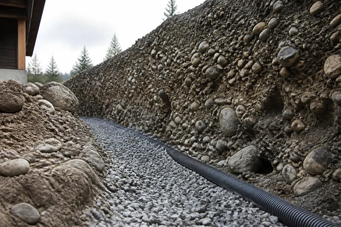
Very little of that describes the ground under Spokane Valley, which is not really soil. It is flood debris — gravel, cobbles and boulders dumped in a hurry at the end of the last ice age, and it behaves unlike almost anything a wall might sit in elsewhere in the country.
Two of the three consequences work in your favor. The third is the one that puts walls over.
Last reviewed: 3 September 2026 against Spokane County’s published material on the Spokane Valley–Rathdrum Prairie aquifer.
What the floods left
At the end of the last glaciation, ice dams impounding Glacial Lake Missoula failed repeatedly. Spokane County describes the result directly: the aquifer beneath the valley is
a combination of gravels, cobbles and boulders — the result of the rapid draining of Glacial Lake Missoula when ice dams broke.
Not silt. Not clay. Rounded stone, some of it very large, in thick layers, sorted by nothing more careful than a wall of water in a hurry.
The permeability that produces is genuinely unusual. The County records the aquifer as having one of the fastest flow rates in the United States, moving as much as 60 feet per day in some areas. Streams crossing it, in the County’s own description, “contact the coarse, gravelly soils overlying the Aquifer and disappear, percolating downward.”
Water put onto this ground goes down, and it goes down quickly.
Why that is good news for a wall
Poor drainage is one of the most common causes of retaining wall failure in most regions. Saturated backfill adds hydrostatic pressure to a structure frequently designed only for soil load, and that pressure is what produces the lean, then the bulge, then the collapse.
Ground that drains this freely removes a great deal of that risk before anything is designed. It is a real advantage of building here, and it is part of why walls in this valley often outlast comparable walls in clay country.
It is not, however, a reason to leave drainage out — because the water that reaches the back of a wall does not only arrive from below.
The failure that does happen here
The native material drains. The material somebody puts behind the wall sometimes does not.
Where a wall is backfilled with site spoil containing topsoil, or with a finer material chosen because it compacted more easily, a low-permeability layer ends up sitting directly against the structure — inside otherwise excellent ground. Water reaching that layer has nowhere convenient to go, and the wall then experiences exactly the loading the surrounding geology would have prevented.
   what the site gives you          what the backfill can undo

   ░░░ free-draining outwash        ░░░ outwash
   ░░░ water moves down fast        ░░░
   ░░░                              ▓▓▓ ← imported fines against the wall
   ░░░                              ▓▓▓   water perches here
   ═══ wall                         ═══ wall, now carrying water pressure
This is a specification and workmanship question, not a site question. Which is why drainage belongs to the wall rather than being an accessory to it: free-draining aggregate immediately behind the structure, a route for collected water to leave, and separation so fines from surrounding soil do not migrate into the drainage zone over the following decade.
On a wall that is already leaning or bulging, what sits behind it is the first thing worth establishing. A structural repair that leaves the original drainage arrangement untouched buys time rather than fixing the cause.
Cobbles change what the digging costs
The other consequence of flood gravel is mechanical, and it shows up in the price rather than the design.
Large rounded stone does not trench cleanly. A footing excavation can meet boulders that have to come out and voids that have to be made good, and the sides of an open excavation in loose cobble do not stand the way they would in a cohesive material.
None of that is unusual here and none of it changes how a wall should be built. It does mean access and excavation deserve settling early, because they affect method and cost more than they would elsewhere, and neither can be judged accurately from a photograph.
Rounded stone also makes poor structural backfill on its own. It is stable after ten thousand years of settlement; re-placed and re-compacted it behaves differently, and compaction behind the wall is what stops the ground above it settling later.
The federal soil classification puts a number on it
There is a regulation that says, in effect, what every excavator here already knows, and it is useful because it turns a feeling about local ground into a dimension you can price.
OSHA’s excavation standard sorts soil into three types by how well it stands up. Type A is cohesive soil with an unconfined compressive strength of 1.5 tons per square foot or greater — clay, silty clay, sandy clay, and cemented soils such as caliche and hardpan. Type C, the least stable classification, expressly includes “granular soils including gravel, sand, and loamy sand,” along with submerged soil or soil from which water is freely seeping.
Glacial outwash is gravel and sand. The standard’s own definition is blunt about what that means: “Granular soil has no cohesive strength.”
The consequence shows up in the sloping tables, and this is the part that reaches your quote. For a simple slope excavation 20 feet or less in depth, Type A soil has a maximum allowable slope of 3/4:1. Type C is 1 1/2:1.
Twice as flat, for the same depth. Every foot down means a foot and a half back on each side rather than nine inches, so the hole is wider, the spoil pile is larger, more material comes out and more goes back. Where the sides are cut vertical instead, the excavation has to be shielded or supported to a height at least 18 inches above the top of the vertical side, which means equipment on site that would not otherwise be there.
None of that is a contractor being cautious or padding a number. It is the classification the ground falls into, and the ground here was laid down by a flood rather than chosen.
Where this changes your reading of a quote. Two bids on the same wall that differ substantially in excavation cost are usually not disagreeing about the wall. They are disagreeing about how the hole gets opened — and a bid that assumes vertical sides with no shielding, on ground the standard classifies as Type C, has priced a job that cannot be dug that way.
The aquifer is not background
The Spokane Valley–Rathdrum Prairie aquifer is not simply groundwater. The EPA designated it a sole source aquifer in 1978 — the second in the nation to receive the designation — and it is the region’s principal drinking water supply.
The same permeability that helps a wall means surface water reaches it fast.
For most residential wall work that is a reason local requirements around excavation, stormwater and material handling exist and are enforced, rather than a constraint in itself. Where a project involves significant regrading, large volumes of imported material, or a change in how surface water leaves a property, the stormwater position is worth establishing with the jurisdiction at design stage. Requirements depend on the authority, the scale of the work and what is being disturbed, so they need checking for the specific project rather than assuming.
What follows from all of it
- The subgrade is usually an advantage. Free-draining ground removes a common cause of wall failure before design starts.
- The advantage is lost if the backfill is wrong. Fines against the back of a wall recreate the problem the site does not otherwise have.
- Uniformity cannot be assumed. Flood deposits vary over short distances, so what is actually under a wall line is a site question — particularly for anything tall, surcharged by a driveway, or engineered rather than decorative.
A wall built with those three understood tends to be a straightforward structure here. The avoidable failures come from building to a generic detail written for somewhere with clay.
Sources
- 29 CFR 1926 Subpart P — Excavations (OSHA) — source of the Type A definition at 1.5 tons per square foot unconfined compressive strength, the Type C definition expressly including granular soils of gravel, sand and loamy sand, the statement that granular soil has no cohesive strength, the maximum allowable slopes of 3/4:1 for Type A and 1 1/2:1 for Type C on simple slope excavations 20 feet or less in depth, and the requirement that a shield or support extend at least 18 inches above the top of a vertical side
- Spokane County — Spokane Valley–Rathdrum Prairie Aquifer — source of the sediment description, the 60 feet per day flow rate and the 1978 sole source designation
- US EPA — Sole Source Aquifer Program
The USGS report on this aquifer (SIR 2005-5227) covers the same ground in more detail. It would not load when this page was written, so nothing here is drawn from it.